Arnarseturshraun – Benediktshellir
Birni Hróarssyni, hellafræðingi, barst nýlega (2009) upplýsingar um hellarásir í Arnarseturshrauni frá áhugasömu hellaskoðunarfólki, Christoph og Sarah Hess.
Þau hjónin höfðu verið að skoða undir  yfirborð hraunsins á svæði suðaustan við Hestshelli og norðvestan við Arnarseturshelli, eins og sjá má á eftirfarandi lýsingum: „Exploring the area. First (a) there were a cave with a VERY narrow entrance, we were inside this one, inside first a small hall 1,2m high, some passages in different directions, one needs to be crawled in (50 cm) but later higher, total length around 30m. I think there was another entrance on the tube. b) Seems to be quite long (just saw in the torchlight deep inside), but was not inside, a rather big entrance, a hall (around 1,2m high), with two or more passages in different directions, one seemed to be quite long. c) Can’t remember this one. d) Quite small, but did not go into, maybe not to be called hraunhellir as it maybe smaller than 20m. e) I think this was a rather big one, some big „bubble“ (diameter 15m) that broke in and is open air, but from this there were different cave passages at least one of them around 20m long and 1,5m high.

It seems that there are hundreds of caves around this area. Maybe one is quite big and we will have another look at it even if it just beneath the surface and quite narrow. Two of them were already marked with a bunch of stones.“
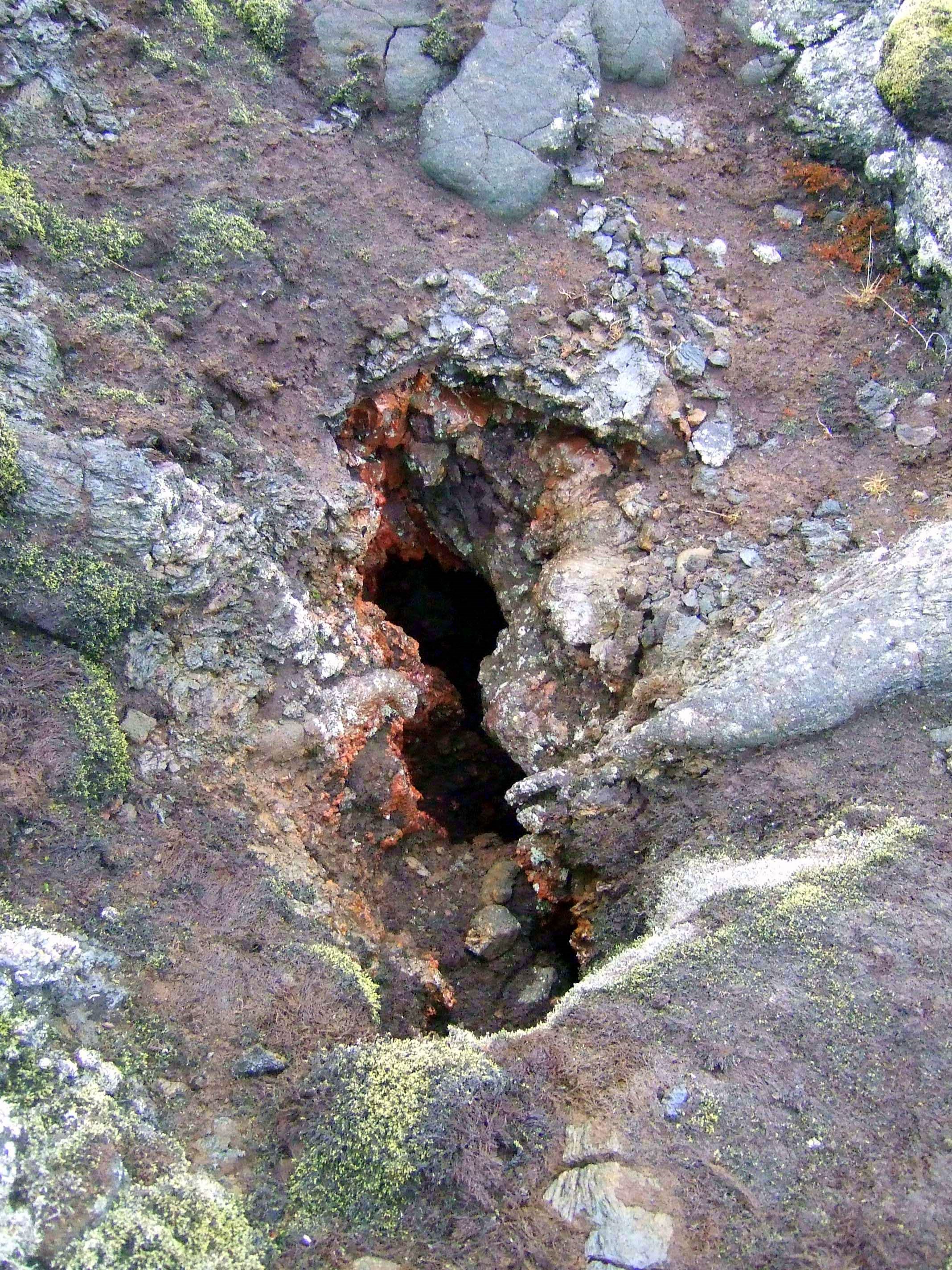
Thank you again for the photos and the forwarded message. Unfortunately I forgot to take my camera with me into the cave, so I only have a photo of the cave entrance in the dark, when we came out. It is a hole (diameter 1 m), with a small cave (not possible to go to the left but you can crawl a bit to the left) and the entrance into the cave is a bit to the right in this hole. It is quite uncomfortable to get in, but this is nothing new for a speleologist and I had to take some stones out of the way to get in at all.

So I finished to redraw a small map of the cave – we did not measure a lot, so it is not accurate, but it should be sufficient.
Maybe your friend wants to take a look at the cave and wants to take some pictures. GPS coordinates for entrance of „Benediktshellir“ are? The other interesting hole we found is here? Maybe he can look at this, too. I totally forgot to take a picture here. But as it is quite big, I am sure you saw this before. As I said, unfortunately it is not possible to get in deep on both sides, just a little bit behind the „niðurfall“.
Svæðið var skoðað (mannskaðaveður með tilheyrandi úrhelli og varla stætt – ofan jarðar).

Hnitin voru staðsett. Þau eru öll nokkurn vegin í línu milli Hestshellis og Arnarseturshellis. Hnappurinn er á ofanverðu svæðinu lengra til suðurs. Allt eru þetta yfirborðsrásir (magaskrið) sem skoðaðar hafa verið áður. Litlar vörður eru við a, b og c (I, II og III), en d og e ( IV og V) eru á svo til sama svæðinu og í sömu rásinni skammt ofan við Hnapp. Þótt rásirnar séu stuttar, lágar og þröngar eru í þeim ágæt myndefni.
Á leiðinni til baka var skoðað í VI og VII. Sá fyrrnefndi hefur stórt op, en ekkert framhald. Litadýrðin er mikil. Hinn síðarnefndi er í grunnu jarðfalli, en skemmtilegt skjól á sléttum stalli (3 m á hæð, 7 á breidd og 10 m á lengd). Undir stallinum eru rauðgulir sveppir á smákafla, en þeir hafa ekki sést í helli áður (að vitað sé)
„Another trip: First we saw a big hole that broke in: 10 m diameter. I think someone else saw this  cave before as it is so big. Unfortunately (as it is such a big broken tube, otherwise it might have been a great cave!) it was to crashed to go in further than 5m. If I have more time maybe I will walk around this thing some meteres, maybe there is another entrance into it and a bigger complete part?!
But we found another one yesterday. And this one seemed to be very interesting. And really the cave was interesting: I think worth to mention in another edition of one of your books 🙂
We called it Benediktshellir (as we are from Germany and the German pope’s name is Benedikt – though we are not catholic. Just to find a name….)
Small description:

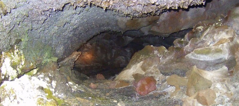
It is a quite narrow entrance with red lava (like Hnappur and not black-gray like the other surfacial caves). So we expected it to be quite deep, especially as we felt a wind coming out of the cave. So I put some broken stones away to have more space to get in. Still it was narrow. and getting slightly down some 3-4 meters 45°. Down we were in a small room (width 3,5m, height 1,6m) with a tube to the right and one to the left, with some nice lava flow formations at the ground. The left one bows to the right after 5m and is going on for about 30m getting narrower, there is a room on the right side going up and the tube ends in a small room diameter 5m and height 0,8m. The ground of this tube is very rough, some stalagtites from the ceiling.

The right tube from the beginning has a long curve (10m) to the left and goes on for about 30m getting down for about 5m on this 30m, but there is a part where the ceiling broke and a very small hole (maybe someone smaller could get through, we decided not to go as it seems quite narrow and the broken stones not very stable), in the light of the torch I saw about 10m further behind these obstacle. Half the way there is a small bridge that divides the tube: a small tube beneath and a nice surface above. The overall color of the cave is red and has some stalagtites.
I drawed a simple map of the cave. The complete length seems to be something about 60m (without the part we did not explore), the average height is about 1,2m. It is a quite nice and interesting cave.“

Eftir nánari skoðun á svæðinu kom eftirfarandi í ljós v/framangreint: „Sá síðarnefndi er sami og merktur er Arnarsetursrásir VII. Rauðgulu separnir eru í honum (jarðfallinu) vestanverðum, en að austanverðu liggur þröng rás up með norðurveggnum. Farið var inn um 10 metra og var þá komið inn í rými (um 1.0 m á hæð). Úr því liggur þrengri rás til austurs að sunnanverðu. Ekki var farið þangað inn (magaskrið). Ólíklegt að þarna kunni að vera rás því komið er svo neðarlega í hraunið (þar sem það sléttast út. Annars er jarðfallið í VII svolítið skemmtilegt jarðfræðilega séð. Þarna hefur kvikan stöðvast um tíma í hraunrásinni og safnast hæglátlega saman, myndað tjörn, sem storknað hefur á yfirborði. Smám saman hefur góandi hraunkvikunni tekist að bræða sig niður og undir yfirborðið sem var um nýja þrönga rás. Við það hefur hólfið tæmst og myndað tómarúm. Þunn loftskelin hefur síðar fallið niður og hólfið þá opinberast að ofan. Á smábletti í henni hafa myndast rauðgular skófir, sem óvíða sjást hér á landi (að vitað sé).
 Bendiktshellir var skoðaður. Rétt norðaustan við opið er falleg hraunrás (yfirborðsrás), stutt en víð (1.20 m á hæð. Opið á Benediktshelli (VIII) er sem fyrr er lýst. Af ummerkjum að dæma var einungis að sjá nýleg spor í mosanum og neðan við opið. Mjög líklega eru þau CH og SH þau fyrstu sem fara þarna niður. Opið virðist lítt áhugavert í fyrstu, jafnvel þegar niður er komið. Erfitt er að þrengja sér lengra niður á milli hvassra steinnybba. Þröng rás virðist áður vera á vinstri hönd, en henni má gleyma. Þegar niður er komið birtist rúmgóð rás, bæði til vinstri og hægri. Hæðin er um 1.60 m g breiddin um 5.0 m. Lýsingin er líkt og sjá má af uppdrættinum, nema hvað hellirinn er meira „afrúnaður“, er í meiri sveig en sýnt er. Uppdrátturinn gefur þó ágæta mynd af aðstæðum. Rásin var þurrr þrátt fyrir rigningartíð undanfarna daga.

Hún er á ca. 5.0 metra dýpi, sem er sú mesta sem er á hraunrásum á þessu svæði svo vitað sé. Önnur rás skammt ofar (VI) er greinilega hluti af sömu hraunrás. Þegar hún var skoðuð mátti sjá sömu liti í kvikunni og þarna. Vinstra megin inni við opið á þeim helli er rás, þröng í fyrstu, en opnast smám saman. Hana þyrfti að magaskríða og er ekki ólíklegt að hún nálgaðist VIII (Benediktshelli). VIII (Benediktshellir) er um 60 m langur (svona við fyrstu athugun). Þverrásir virðast hafa verið skammvinnar hliðakvikuþrær, sem hafa gengi til baka inn í meginrásina þegar losnaði um.
Hnappur er nokkuð suðaustan við þetta rásarsvæði. Lægð er á millum. Megingígar Arnarseturshrauns (hafa ber í huga að um gos á sprungurein er að ræða og sumir gígarnir því umverpst hrauninu) eru enn lengra í suðaustur (sunnan við Arnarseturshelli). Hraunið stallast þarna og er Bendiktshellir á miðstallinum. Þar eru einnig fleiri skemmilegar rásir, sem vert væri að skoða nánar.
Hnappur – opið.


